
It was a quarter before 5:00 AM. Not as I expected, the outpost designated for hiker's registration was not bursting with crowd. That, I guess, is the advantage of starting the hike at dawn if the mountain you wish to summit is a popular day hike destination and nestles just a stone's throw away from Metro Manila. From listing our names to prepping up ourselves at the jump-off, there's no queue; everything was smooth-sailing unlike in my past hiking trips.
READ ALSO: Destined for Daraitan: Tinipak River and Mt. Daraitan Experience

The trek commenced at past five as planned. Apart from the patches of the trail that our headlamps shine light upon, the entire forest was in total darkness. But the intermittent howling breeze that almost kept us from sweating gave us that sense of being in commune with nature. Mt. Maculot was third among the peaks I've been to, but the first trail that I had trekked along while blackness keeps the verdant environs from sight. It was such an experience, I must say, when the mountain you are into slowly reveals to you, all the horizon from her point of view.


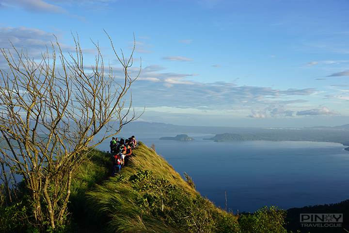
In an hour and a half, we reached a resting spot from which there was a familiar sight — a scenic view of Taal Lake and surrounding cliffs — a stunning visual of Maculot that I often see on social media. At this point, the morning has broken. Few more meters from there was the campsite where the trail part ways; one path goes all the way up to the summit, and the other leads to the Rockies. Maculot has three distinguished parts: its summit, the Rockies, and the Grotto that soars on the traversed side.


Past the path fringed with semi-tall wild grass and a fenced facility that houses some equipment used to monitor Taal Volcano's activity, Maculot Rockies dawns upon everyone. I'd been clueless about why the term "rockies" always comes with the popular hiking destination. Here's what I learned: from a vantage point somewhere along the trail, the Rockies seems like a separate land mass with protruding rocks scattered all over it; hence the name. A hill that rises at 706 MASL, the Rockies is considered the mountain's "sub-summit". Most hikers, if not all, opt to trek up the Rockies first before the summit.


Reaching the Rockies' crest requires trekking down across roped trail segments, and then assaulting the uphill path that cuts in between sharp-edged boulders. It was quite a muscle-pumping endeavor but at the top, the vista is all worth-it. On my left, there's the entirety of Taal Lake that cradles the majestic Taal Volcano Island, a miniature view of buildings at the highlands of Tagaytay, and other shadowy peaks and islands nearby. On my right, there's the sun that had risen from behind the cloudy summit, just in time when we arrived.


We went down the Rockies before it got crowded and arrived back at the campsite shortly. Pancit Canton breakfast at last. I don't know if it's just me, but this instant noodles is a hiking delicacy; it's yummier up there in the mountains.

At the summit, it wasn't the panoramic view that counts but that being able to reach the summit per se. Rockies captivates hikers with the same vista, but being at the peak gives a sense of achievement. That feeling when you successfully ticked another mountain off your bucket list — a distinguished one, the second highest point in Batangas, to be exact.
A man sells buko (coconut) juice at the peak. It's been a perfect thirst quencher while savoring the moment at 930 meters above sea level. Like while we're at the Rockies, we started descending Maculot when fellow hikers started to fill the summit.


The packed lunch from McDonald's and about 45 minutes of respite were a breather. We're ready to hike up a bit towards the Grotto. On top, it was a calming view — Cuenca's green plains patched with contiguous houses kiss the clear sky painted by that day's fine weather. It was around 11:30 AM and the sun was at its peak. I barely saw trees that would shed us from the sun's scorching heat as we trek down through the Grotto's concrete staircase that passes by the 14 Stations of the Cross, each station placed at a relative distance from one another. It was then that I realized what my friend meant by that "challenging part of Maculot" — it wasn't all the rappelling and thorny bushes. It was this knee-jerking descent down to the exit point after the hike that started six hours prior.

We arrived at the foot of Mt. Maculot free from blunders, except for some tiny scratches ripped by those spiky stems. There was the shower station. Then there were the tricycles that would bring us back to downtown Cuenca. It's only 1:00 PM but it's been a day enough for me. Fifteen minutes more for the tricycle ride and it's time for the hearty Batangas lomi. Been there, done that.
READ ALSO: A Twist to Your Favorite Batangas Lomi at Lipa's Sizzling Lomi House

Here's a travel guide should you be hiking soon: TRIP GUIDE: Mt. Maculot Day Hike (Traverse)
This a part of a self-imposed quest. In January 2018, I challenged myself to reach ten mountain peaks before the year ends (doing it as well for a healthier self). Follow me as I also share this adventure on Facebook and Instagram at @pinoytravelogue.
READ ALSO: Destined for Daraitan: Tinipak River and Mt. Daraitan Experience
The trek commenced at past five as planned. Apart from the patches of the trail that our headlamps shine light upon, the entire forest was in total darkness. But the intermittent howling breeze that almost kept us from sweating gave us that sense of being in commune with nature. Mt. Maculot was third among the peaks I've been to, but the first trail that I had trekked along while blackness keeps the verdant environs from sight. It was such an experience, I must say, when the mountain you are into slowly reveals to you, all the horizon from her point of view.
In an hour and a half, we reached a resting spot from which there was a familiar sight — a scenic view of Taal Lake and surrounding cliffs — a stunning visual of Maculot that I often see on social media. At this point, the morning has broken. Few more meters from there was the campsite where the trail part ways; one path goes all the way up to the summit, and the other leads to the Rockies. Maculot has three distinguished parts: its summit, the Rockies, and the Grotto that soars on the traversed side.
Maculot Rockies
At the campsite stands a makeshift store that sells light snacks and refreshments, from which, instant Pancit Canton lures every tired soul that arrives. I would've fallen into its sating spell if not with my buddies that woke me up, urging me to scale the Rockies beforehand. I obliged.Past the path fringed with semi-tall wild grass and a fenced facility that houses some equipment used to monitor Taal Volcano's activity, Maculot Rockies dawns upon everyone. I'd been clueless about why the term "rockies" always comes with the popular hiking destination. Here's what I learned: from a vantage point somewhere along the trail, the Rockies seems like a separate land mass with protruding rocks scattered all over it; hence the name. A hill that rises at 706 MASL, the Rockies is considered the mountain's "sub-summit". Most hikers, if not all, opt to trek up the Rockies first before the summit.
Reaching the Rockies' crest requires trekking down across roped trail segments, and then assaulting the uphill path that cuts in between sharp-edged boulders. It was quite a muscle-pumping endeavor but at the top, the vista is all worth-it. On my left, there's the entirety of Taal Lake that cradles the majestic Taal Volcano Island, a miniature view of buildings at the highlands of Tagaytay, and other shadowy peaks and islands nearby. On my right, there's the sun that had risen from behind the cloudy summit, just in time when we arrived.
We went down the Rockies before it got crowded and arrived back at the campsite shortly. Pancit Canton breakfast at last. I don't know if it's just me, but this instant noodles is a hiking delicacy; it's yummier up there in the mountains.
Summit
We're ready to take the other side of the parting trail after the quick mountain treat. This time, the path leads to the summit. If not because of the mud — it rained days before our hike — getting to the summit would have been a lot less demanding than getting to the Rockies crest. We reached the apex within an hour and 15 minutes. Up there was an equally breathtaking view on a higher standpoint but I must admit, I got more enthralled while I was at the Rockies.At the summit, it wasn't the panoramic view that counts but that being able to reach the summit per se. Rockies captivates hikers with the same vista, but being at the peak gives a sense of achievement. That feeling when you successfully ticked another mountain off your bucket list — a distinguished one, the second highest point in Batangas, to be exact.
A man sells buko (coconut) juice at the peak. It's been a perfect thirst quencher while savoring the moment at 930 meters above sea level. Like while we're at the Rockies, we started descending Maculot when fellow hikers started to fill the summit.
Grotto
We had taken the traverse trail. A friend of mine who has been there before tipped me off that this route was where Maculot keeps all its difficulty. I must say he's right. Given that the descent is more difficult than the hike up (because the limbs have already been pumped up), Maculot's traverse path has segments where trekkers need to carry themselves down through ropes. In certain areas, trunks that hikers tend to hold on with force and some vines that obstruct the footpath were filled with thorns. All of these we had to deal with before reaching the foothill of the Grotto and had our early lunch there.The packed lunch from McDonald's and about 45 minutes of respite were a breather. We're ready to hike up a bit towards the Grotto. On top, it was a calming view — Cuenca's green plains patched with contiguous houses kiss the clear sky painted by that day's fine weather. It was around 11:30 AM and the sun was at its peak. I barely saw trees that would shed us from the sun's scorching heat as we trek down through the Grotto's concrete staircase that passes by the 14 Stations of the Cross, each station placed at a relative distance from one another. It was then that I realized what my friend meant by that "challenging part of Maculot" — it wasn't all the rappelling and thorny bushes. It was this knee-jerking descent down to the exit point after the hike that started six hours prior.
We arrived at the foot of Mt. Maculot free from blunders, except for some tiny scratches ripped by those spiky stems. There was the shower station. Then there were the tricycles that would bring us back to downtown Cuenca. It's only 1:00 PM but it's been a day enough for me. Fifteen minutes more for the tricycle ride and it's time for the hearty Batangas lomi. Been there, done that.
READ ALSO: A Twist to Your Favorite Batangas Lomi at Lipa's Sizzling Lomi House
Here's a travel guide should you be hiking soon: TRIP GUIDE: Mt. Maculot Day Hike (Traverse)
This a part of a self-imposed quest. In January 2018, I challenged myself to reach ten mountain peaks before the year ends (doing it as well for a healthier self). Follow me as I also share this adventure on Facebook and Instagram at @pinoytravelogue.
ABOUT

DJ Rivera is an I.T. professional, entrepreneur, travel blogger, writer and the online publisher of PinoyTravelogue.com based in Rizal province, Philippines. Click here to know more.
