
 |
One Sunday afternoon, my friend Nico and I were bound for Kasarinlan Park in Baras, already cycling the last kilometers when it suddenly drizzled. We could have driven straight to the park if the light rain did not turn into buckets, but as we raced against the lighter shower, the weather became more unforgiving.
We're still in Morong town, pedaling along the highway portion that cuts between open green fields, so we had no choice but to take shelter under one of the trees that fringed the road.
The rain did not relent for about 30 minutes. While waiting, our chitter-chatter turned to the yellow concrete post with number and letter markings on it. "Alam mo ba kung para saan yan?" (Do you know what's that for?), I initiated.
READ ALSO: Mt. Tagapo: An Underrated Hiking Destination
There was an old belief that having dreams about random numbers, or spotting a number on random things (like tree barks or under the leaves, they say), foretells great luck in the lottery. Thus, when I was in my teenage years, I took note of the numbers whenever I caught sight of those kilometer markers. Haha!
I learned the truth about these kilometer markers (or kilometer posts) when I got hooked to traveling and started riding motorcycles years ago. I told Nico that misty afternoon how to read, or shall I say decipher, the meaning of those post markings and what it's for.
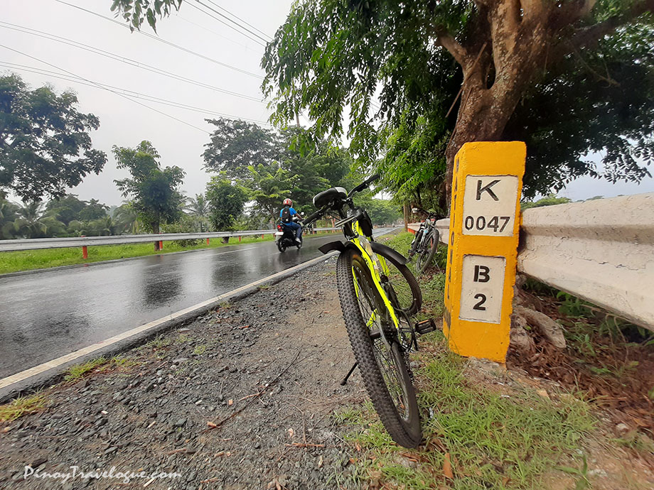
With the particular marker on where we found shelter (photo above):
- The "K" on the upper white box simply means "kilometer", and the "0047" denotes the magnitude for that unit of measuring distance. So, the marker conveys that that exact point where it stands is 47 kilometers from a certain point. That point is the Kilometer Zero (or KM 0) marker located in Luneta Park, Manila. In essence, kilometer posts tell us how far we are from the nation's capital.
- The lower white box, with "B" and "2", indicates the next town center you're approaching and how far it is from where the marker stands. In where we stood, driving forward would reach Baras, hence the "B", and its town center is only two kilometers away, hence the "2". Just how unlucky we were that day, the destination was already within our reach!
- Moreover, if the marker stands on the right side of the road, it means you're driving away from KM 0 while otherwise if it stands on the left. The reverse side of the marker above has "M" on it, telling drivers from the other side that they are approaching Morong's main thoroughfare.
What I told Nico was what that particular marker's all about. Kilometer posts around the country vary in some ways. The paint, for instance, is mostly dominant yellow and white, but some markers are dominant white; some are pure yellow (markings are engraved in black) and some are not painted at all—markings are in contrast with the concrete's earthy hue. Even the KM 0 in Luneta appears differently; it is life-size and aesthetically designed with a sketch of the Philippine map above its "KM 0" marking.
READ ALSO: Binondo Binge: Top 8 Food Trip Destinations of Manila Chinatown
Letter markings sometimes vary too. The "K" in the above marker in Baras, Rizal is written as "KM" in other markers elsewhere (marker's connotation is easier to guess that way). The usual single letter that denotes the next town also varies when, for example, the next two adjacent towns have similar initial letters; in such case, the marking becomes two letters in order to distinguish one town from the other.
On another note, there are more than one Kilometer Zero markers around the country. Some islands, mostly major islands or island provinces such as Cebu and Batan Island (Batanes), have KM 0 markers installed in where the highest seat of government in that island is located, e.g., in the provincial capitols in Cebu City and in Basco, Batanes. Those KM 0's are the reference points of roads within the islands.
READ ALSO: Magellan's Cross: Of History, Culture, and Proof of Travel
You probably know that in Mindanao, there's a large KM 0 marker in Marawi City with an inscription below it that says "Original reference point of all roads in Mindanao". Photos of it have circulated the social media for some time because of tourists that have visited. National roads across Luzon island are measured from the KM 0 in Luneta which is also in use of a highway that spans across the archipelago.
When Pan-Philippine Highway (or Maharlika Highway)—the longest road network in the country that stretches around 3,500 kilometers, connecting Luzon, Visayas (through Samar and Leyte), and Mindanao—was completed, the marker in Luneta was used as its reference point. So, the next time you take a road trip along segments of this highway in Mindanao, expect to see markers denoting a thousand kilometers. It tells you that you're a thousand kilometers from the marker in Manila, not from the marker in Marawi.
These usually yellow concrete posts predate Waze and Google Maps in aiding drivers and travelers during navigation, though still an alternative when GPS freezes during road trips because of sporadic mobile network signal. It is not, as I believed in the past, a golden number to place a bet on the lottery. Or you could could be that lucky, who knows?
This is what I know so far about this seemingly complex subject. Feel free to share additional facts about them or correct me if I'm wrong in some parts. Thanks!
ABOUT

DJ Rivera is an I.T. professional, entrepreneur, travel blogger, writer and the online publisher of PinoyTravelogue.com based in Rizal province, Philippines. Click here to know more.
